 Filter: Categories of Wisconsin Historical Images
Filter: FULL_DATE of 1791
Filter: Categories of Wisconsin Historical Images
Filter: FULL_DATE of 1791

| Date: | 1791 |
|---|---|
| Description: | An English and updated version of d'Anville's 1746 map "Amérique Septentrionale Publiée sous les Auspices de Monseigneur le Duc d'Orleans Prémier Prince du... |
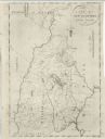
| Date: | 1791 |
|---|---|
| Description: | Detailed map of New Hampshire. It shows counties, cities, mountains, highlands, lakes, and rivers. The acres given to Dartmouth College are labeled far in ... |

| Date: | 1791 |
|---|---|
| Description: | Small map of an abandoned Native American town and fort at the junction of the Ohio and Muskingum River. It shows the fortifications, an outline of the tow... |
If you didn't find the material you searched for, our Library Reference Staff can help.
Call our reference desk at 608-264-6535 or email us at: